![](/images/other/stat-length.png)
![Trail On foot Stara Bystrzyca - Dolina Tocznej - Photo](https://media.geolcdn.com/t/1900/400/ext.pjpeg?maxdim=2&url=https%3A%2F%2Fmedia.geolcdn.com%2Ff%2F0b27b34c-d333-4b56-a3c3-4cbcad77df96.jpeg)
Dolina Tocznej
SityTrail - itinéraires balisés pédestres
Tous les sentiers balisés d’Europe PRO
![Length](/images/other/stat-length.png)
Length
3.4 km
![Max alt](https://static1.geolcdn.com/siteimages/upload/files/1508320355ic_sort_altitude_max_24dp.png)
Max alt
496 m
![Uphill gradient](https://static1.geolcdn.com/siteimages/upload/files/1508320355ic_sort_den_pos_24dp.png)
Uphill gradient
95 m
![Km-Effort](/images/other/stat-length.png)
Km-Effort
4.7 km
![Min alt](https://static1.geolcdn.com/siteimages/upload/files/1508320355ic_sort_altitude_min_24dp.png)
Min alt
402 m
![Downhill gradient](https://static1.geolcdn.com/siteimages/upload/files/1508320355ic_sort_den_neg_24dp.png)
Downhill gradient
97 m
![Boucle](https://static1.geolcdn.com/siteimages/upload/files/16400158638029165_repeat_loop_refresh_sync_direction_icon.png)
Boucle
Yes
Signpost
Creation date :
2022-02-16 17:22:20.153
Updated on :
2022-03-08 14:15:27.124
![On foot](https://static1.geolcdn.com/sitytour/trail-icons/100.png)
1h03
Difficulty : Easy
![Scan this QR Code to open this trail in the SityTrail application](https://capi.geolives.com/qq0zvz2zws4bq2lad0pu/sitytour/trails/3129508/qr.png?size=200)
FREE GPS app for hiking
About
Trail On foot of 3.4 km to be discovered at Lower Silesian Voivodeship, Kłodzko County, Stara Bystrzyca. This trail is proposed by SityTrail - itinéraires balisés pédestres.
Description
Trail created by Nadleśnictwo Bystrzyca Kłodzka.
Symbol: unmarked
Positioning
Country:
Poland
Region :
Lower Silesian Voivodeship
Department/Province :
Kłodzko County
Municipality :
Stara Bystrzyca
Location:
Unknown
Start:(Dec)
Start:(UTM)
615083 ; 5572004 (33U) N.
Comments
Trails nearby
![Trail On foot Długopole Dolne - Leśny Zdrój - Photo](https://media.geolcdn.com/t/375/260/ext.jpg?maxdim=2&url=https%3A%2F%2Fmedia.geolcdn.com%2Ff%2Fbe03d1a7-16e2-4dbe-bb3a-1a01af08bf1f.jpeg)
![On foot On foot](https://static1.geolcdn.com/sitytour/trail-icons/100.png)
Leśny Zdrój
On foot
Easy
Długopole Dolne,
Lower Silesian Voivodeship,
Kłodzko County,
Poland
![](/images/other/stat-length.png)
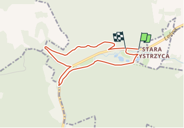
4.3 km | 5.9 km-effort
1h 20min
![](https://static1.geolcdn.com/siteimages/upload/files/16400158638029165_repeat_loop_refresh_sync_direction_icon.png)
Yes